Interactive maps of transport data
I saw Steve's link to this very interesting work on transportation maps . All I can say is wow, this is great!
I saw Steve's link to this very interesting work on transportation maps . All I can say is wow, this is great!
| tags: blind, maps, enabling technology
Some maps Diane sent to help us think about text-based maps. She said:
I have faxed several maps to you. Eastern Alamance High School is a series of buildings connected by covered sidewalks. On my map, the buildings are shaded yellow. The section with X and circles (bushes) is the outside courtyard. There is a map of Northgate Mall (Durham). I have a poor map of GMS. The last map is a street map of the area around GMS. The numbers on this map correspond with restaurants (see last page).
| tags: maps, enabling technology
Interesting looking book on text adventure and interactive fiction.
| tags: maps, ideas, enabling technology
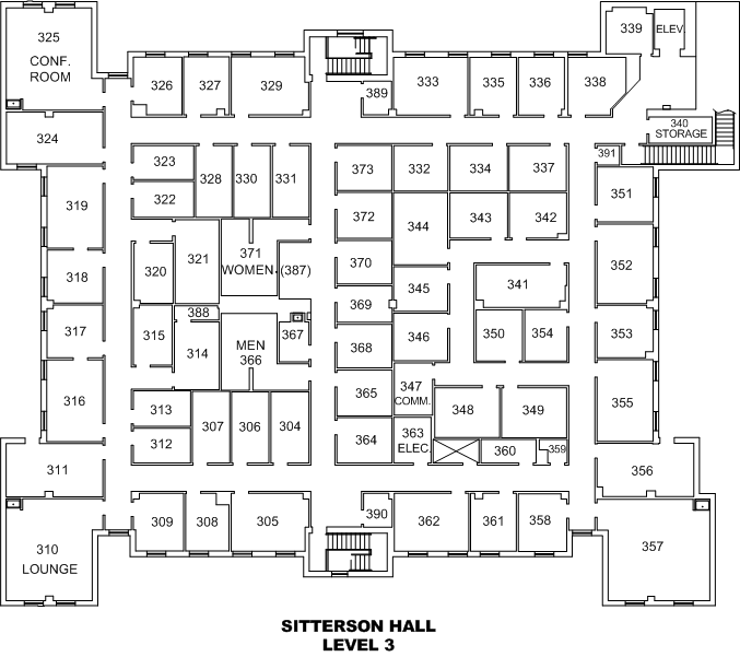 Americo studied the floorplans for Sitterson and verified them by examination while producing a description of each
place
in the building. I built a simple prototype web server but I’m unsatisfied with its dependence on coordinates and the resulting difficulty of sorting the links in hallways into a reasonable order.
Americo studied the floorplans for Sitterson and verified them by examination while producing a description of each
place
in the building. I built a simple prototype web server but I’m unsatisfied with its dependence on coordinates and the resulting difficulty of sorting the links in hallways into a reasonable order.
| tags: maps, ideas, enabling technology
I got an email and phone call from Rachel Magario, a blind geography graduate student at the University of Kansas. She is interested in maps for people who are blind and is specifically interested in making an accessible map of her campus. She wants something like BATS embedded in the browser. I explained to her how hard that would be with the poor support for sound and non-existent support for tactile feedback in browsers.