 |
History |
| Skip to content |
| Home |
| News |
| History |
| Current Work |
| Papers |
| Features |
| Downloads |
| User Manual |
| Links |
| Acknowledgements |
| Contact |
| Text-only site |
| UNC Assistive Technology |
How it Started
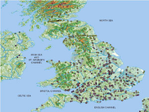
The first BATS prototype was designed by five undergraduate students under the guidance of Professor Gray Bishop at the University of North Carolina-Chapel Hill in the spring of 2002. The project idea stemmed from a chance meeting on campus between Dr. Bishop and Jason Morris, a visually impaired graduate student in the classics department. Dr. Bishop's long-running interest in assistive technology, Jason's difficulty in working with tactile maps in his research, and the team's motivation to work on a worthwhile project all lead to the development of an initial prototype. Collaboration with the Ancient World Mapping Center at UNC kick-started the project with data for a map of ancient England complete with 393 ancient city names, ancient city types, modern city names, and distances as well as 307,200 point elevations. BATS made this rich set of data accessible to Jason so that he was could gain a keen awareness of its content--keen enough to write a paper relating distances between settlements and the structure of Roman government at its time of occupation.
BATS: Roman Britain
 The BATS: Roman Britain prototype augments a digital map of ancient England with a number accessibility features to support exploration by a blind user. Text-to-speech synthesis delivers information from user queries into spatial data including location names, location types, and elevations to name a few. Spatial sounds provide a context for user exploration by playing audio cues in the corresponding directions and distances from the users current cursor location on the map. Searching for specific locations and calculating relational distances between two points of interest are also made easy by the software.
In a typical session with the BATS: Roman Britain prototype, a user uses a mouse, trackball, or tablet input device to move a pointer over the map. The numeric keypad on the keyboard is used to perform a number of actions such as listening to environmental sounds in a given compass direction from the user's current position, requesting the spelling of a given city's name, and querying a settlement's type.
BATS: North Carolina
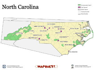 The BATS: North Carolina prototype was implemented in the fall of 2002. This second system features a number of marked improvements over the original including spatial sound environments that update in real-time during exploration, tactile vibrations and textures in areas of interest, and a simplified user interface geared towards younger students. Many of the ideas present in the North Carolina demo are proofs of concept for our current work. This demo is also available for download for the public as a demonstration of some of the features we plan to include in the full version of BATS.
As a user explores the map of North Carolina, she is immersed in an environment of real-time sounds and textures. She can move towards regions of interest based on the direction of their iconic sounds. For example, sounds of birds chirping that come from the left indicate that a forest is nearby to the west. Furthermore, she receives information through tactile feedback. Cities, for instance, cause a tactile mouse or gamepad to vibrate when the cursor hovers over these regions of importance. Once the user nears her destination, information about local landmarks becomes available. A click of a button prompts local landmarks to announce their names from their respective directions. Another button provides detailed information about ther user's current location; for example: name, population, area, and perimeter can be queried on demand.